Difference between revisions of "MRP: Hatton Garden"
| Line 28: | Line 28: | ||
===Image credits & copyright information=== | ===Image credits & copyright information=== | ||
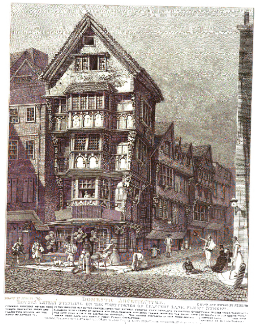
| − | (1) 'Houses lately standing on the west corner of Chancery Lane, Fleet Street', John Thomas Smith, Ancient topography of London: containing not only views of buildings ... but some account of places and customs either unknown, or overlooked by the London historians (London, 1815, repr. 1892), plate, betw. pp. 48 & 49 | + | (1) 'Houses lately standing on the west corner of Chancery Lane, Fleet Street', John Thomas Smith, ''Ancient topography of London: containing not only views of buildings ... but some account of places and customs either unknown, or overlooked by the London historians'' (London, 1815, repr. 1892), plate, betw. pp. 48 & 49 |
| + | - Book and image are out of copyright | ||
| + | - Image sourced from Internet Archive edition | ||
---- | ---- | ||
==Town profile== | ==Town profile== | ||
| Line 63: | Line 65: | ||
[http://www.hrionline.ac.uk/strype/images/figures/810014-001.jpg Richard Blome, 'A Mapp of Farringdon without ward,' pub. in John Strype’s ''A Survey of London'' (XXXX, XXXX)] | [http://www.hrionline.ac.uk/strype/images/figures/810014-001.jpg Richard Blome, 'A Mapp of Farringdon without ward,' pub. in John Strype’s ''A Survey of London'' (XXXX, XXXX)] | ||
| + | ===Survey of Hatton Garden, Abraham Arlidge, 1694=== | ||
| + | |||
| + | [http://www.library.jhu.edu/bin/t/g/hattongarden.jpg Arlidge, Abraham, 'A survey of Hatton Garden, 1684,' [London]: Manuscript, Reproduction, Westerham Press, 1983. 64 x 79 cm.]<ref>www.library.jhu.edu/bin/t/g/hattongarden.jpg, viewed 19/05/11</ref> | ||
| + | - NOTE: This description is inconsistent with London Topographical Record vol. 25. 220 pages, 38 maps and illustrations. Publication no 132 (1985). £12. Contains papers on: The Survey of Hatton Garden in 1694 by Abraham Arlidge | ||
---- | ---- | ||
==Suggested primary sources== | ==Suggested primary sources== | ||
Revision as of 20:44, January 1, 2012
Hatton Garden
Editorial history
26/12/11, CSG: Created page
Contents
Suggested links
See Grays Inn chambers, London
See Gray's Inn walks, London
Images
Map
Insert Map of situation
Town plan
Insert Town plan
West corner of Chancery Lane & Fleet Street
Image credits & copyright information
(1) 'Houses lately standing on the west corner of Chancery Lane, Fleet Street', John Thomas Smith, Ancient topography of London: containing not only views of buildings ... but some account of places and customs either unknown, or overlooked by the London historians (London, 1815, repr. 1892), plate, betw. pp. 48 & 49
- Book and image are out of copyright
- Image sourced from Internet Archive edition
Town profile
Notes
Mentions of Hatton Garden in Wiki primary sources
Inventories
Law suits
Letters
Wills
Suggested image sources
Map of St. Andrew's, Holborn, Richard Blome, John Strype's London
Map of Farringdon without ward, Richard Blome, John Strype's London
Survey of Hatton Garden, Abraham Arlidge, 1694
Arlidge, Abraham, 'A survey of Hatton Garden, 1684,' [London: Manuscript, Reproduction, Westerham Press, 1983. 64 x 79 cm.][1]
- NOTE: This description is inconsistent with London Topographical Record vol. 25. 220 pages, 38 maps and illustrations. Publication no 132 (1985). £12. Contains papers on: The Survey of Hatton Garden in 1694 by Abraham Arlidge
Suggested primary sources
TNA
Suggested secondary sources
- ↑ www.library.jhu.edu/bin/t/g/hattongarden.jpg, viewed 19/05/11
